


Maverick
GPS Navigation

คำอธิบายของMaverick: GPS Navigation
Use offline maps and GPS even without an internet connection. This app is great for hiking, boating, geocaching and other outdoor activities.
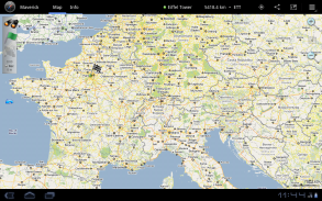
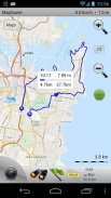
• Multiple global and regional online maps, including: Bing, Yandex, Open Street Maps, OSM Cycle, OSM Public Transport, Multimap (UK), OutdoorActive (Germany, Austria, South Tyrol), Cykloatlas, HikeBikeMap (Germany), Open Piste Map, NearMap (Australia) and many other maps.
All maps automatically cached for offline use. Use Mobile Atlas Creator to download maps or MAPC2MAPC to convert maps from other formats.
• Share your current or planned position
You can send address, GPS coordinates, link to Google Maps and even map image.
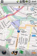
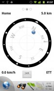
• Navigate easily
Build-in radar shows the direction, distance and estimated time to a point of interest.
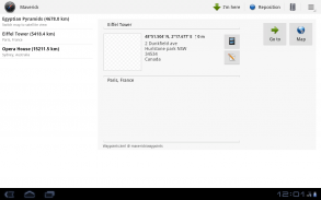
• Save places you visit
All waypoint stored in KML file and can be viewed and edited in Google Earth.
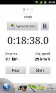
• Record tracks with single tap
Tracks are recorded in GPX format and can be viewed in Google Earth and other software.
• Upload tracks to GPSies
Free account is required for uploading.
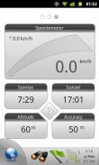
• Trip Computer
Watch speed, altitude, pitch and many other values.
Only in Pro version:
• Unlimited waypoints and tracks
• Lock compass to bearing
• UTM and OSGB grids
• OS Explorer maps
• FourSquare support
We can implement standard Google MapView, but it's limited - no caching and terrain view. If you need it, please email us or leave a comment.
</div> <div jsname="WJz9Hc" style="display:none">การใช้แผนที่แบบออฟไลน์และจีพีเอสได้โดยไม่ต้องเชื่อมต่ออินเทอร์เน็ต app นี้เป็นที่ดีสำหรับการเดินป่า, พายเรือ, geocaching ที่และกิจกรรมกลางแจ้งอื่น ๆ
•หลายแผนที่ออนไลน์ระดับโลกและภูมิภาครวมไปถึง: Bing, Yandex, เปิดถนนแผนที่วงจร OSM, OSM การขนส่งสาธารณะ, Multimap (สหราชอาณาจักร) OutdoorActive (เยอรมนี, ออสเตรีย, South Tyrol) Cykloatlas, HikeBikeMap (เยอรมนี), เปิด Piste แผนที่ , Nearmap (ออสเตรเลีย) และแผนที่อื่น ๆ อีกมากมาย
แผนที่ทั้งหมดที่เก็บไว้โดยอัตโนมัติสำหรับการใช้งานแบบออฟไลน์ ใช้มือถือ Atlas ผู้สร้างดาวน์โหลดแผนที่หรือ MAPC2MAPC การแปลงแผนที่จากรูปแบบอื่น ๆ
•แบ่งปันตำแหน่งปัจจุบันหรือตามแผนของคุณ
คุณสามารถส่งที่อยู่พิกัด GPS เชื่อมโยงไปยัง Google Maps และแม้กระทั่งภาพแผนที่
•นำทางได้อย่างง่ายดาย
Build-in เรดาร์แสดงให้เห็นทิศทางที่ระยะทางและเวลาที่คาดว่าจะจุดที่น่าสนใจ
•สถานที่บันทึกคุณเยี่ยมชม
waypoint ทั้งหมดที่เก็บไว้ในไฟล์ KML และสามารถดูและแก้ไขใน Google Earth
•แทร็คที่บันทึกด้วยการแตะเพียงครั้งเดียว
เพลงจะถูกบันทึกในรูปแบบ GPX และสามารถดูได้ใน Google Earth และซอฟต์แวร์อื่น ๆ
•อัพโหลดติดตามการ GPSies
บัญชีฟรีเป็นสิ่งจำเป็นสำหรับการอัปโหลด
•คอมพิวเตอร์การเดินทาง
ดูความเร็วสูงสนามและค่าอื่น ๆ อีกมากมาย
เฉพาะในรุ่น Pro:
•จุดไม่ จำกัด และแทร็ค
•เข็มทิศล็อคไปแบริ่ง
• UTM และกริด OSGB
•แผนที่สำรวจ OS
•สนับสนุน FourSquare
เราสามารถใช้ Google มาตรฐาน MapView แต่ก็ จำกัด - แคชและดูภูมิประเทศที่ไม่มี หากคุณต้องการมันโปรดส่งอีเมลถึงเราหรือแสดงความคิดเห็น</div> <div class="show-more-end">
Maverick: GPS Navigation--เวอร์ชั่น2.7.4
(12-10-2015)
Maverick: GPS Navigation - ข้อมูล APK
เวอร์ชั่น APK: 2.7.4แพ็คเกจ: com.codesector.maverick.liteเวอร์ชั่นล่าสุดของMaverick: GPS Navigation
เวอร์ชั่นอื่น


แอปในประเภทเดียวกัน


